Microsoft Virtual Earth updated - 26TB of new data added

Posted on Sunday, July 08 2007 @ 21:39 CEST by Thomas De Maesschalck
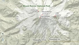
Microsoft has published its July update for Virtual Earth, adding 26 terabytes of new map data. This includes new aerial imagery, 3D buildings and Birds Eye imagery but also a new feature called "hill shading" which gives the road style maps the ability to convey elevation. Click here for an example.

Here's a rundown of what else is new this month. All of these cities/regions have new or expanded Aerial imagery and most have textured 3D buildings and cityscapes

Canada: Hamilton, Quebec, Toronto (Montreal is on the way in our next release)

Europe: Toulouse France, Eastbourne UK

United States: Birmingham, Huntsville, Montgomery, Mobile, Phoenix (expanded), Arden, Denver (expanded), Ft. Lauderdale, Jacksonville, West Palm Beach, Tallahassee, Fort Myers, Tampa West, St Petersburg, Coral Gables, Cape Coral West, Pembroke Pines, Orlando, Hialea, Columbus GA, Jackson, Oak Park IL, Rockford IL, Ohare IL, Baton Rouge, Shreveport New Orleans, Metarie, Jersey City, Elizabeth, East Ruth, Newark, Paterson, Brooklyn, Niagara Falls, Portland (expanded), Nashville, Chattanooga, Milwaukee


About the Author

Thomas De Maesschalck

Thomas has been messing with computer since early childhood and firmly believes the Internet is the best thing since sliced bread. Enjoys playing with new tech, is fascinated by science, and passionate about financial markets. When not behind a computer, he can be found with running shoes on or lifting heavy weights in the weight room.


Loading Comments